
 Mountain Wrecker Wayne Fishback Faces Lengthy Jail Time
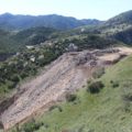
January 13, 2020 EnviroReporter.com has reported this story for 14 years. More evidence of money Fishback made off of Browns Canyon dump in western L.A. County. Landslide potential of both dumps analyzed. Ventura County’s dump could fail and collapse downhill in a 45-foot-wide and 3-foot-deep dumpslide at 20 miles per hour aimed at Simi Valley. Judge gives Fishback 60 days for cleanup plan or he’ll be jailed. Clean up Fishback Mountain within 180 days or potentially jail again.
 DUMPED: Wayne Fishback in Browns Canyon
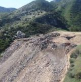
June 6, 2018 Massive dump above Chatsworth with 5.7 times the amount of concrete rubble, debris, rebar, garbage and junk all dumped in once-beautiful mountains. Ten photographic forays into Browns County captured the scope and breadth of this destruction for four years. 2014 to 2017 Galleries
2014 – 2017

Wayne Fishback Browns Canyon December 19, 2014 - 13 photographs
13 Photos

Wayne Fishback Browns Canyon January 25, 2015 - 58 photographs
58 Photos

Wayne Fishback Browns Canyon March 5, 2015 - 56 photographs
56 Photos

Wayne Fishback Browns Canyon March 28, 2015 - 37 photographs
37 Photos

Wayne Fishback Browns Canyon June 29, 2015 - 35 photographs
35 Photos

Wayne Fishback Browns Canyon September 24, 2015 - 25 photographs
25 Photos

Wayne Fishback Browns Canyon November 5, 2015 - 26 photographs
26 Photos

Wayne Fishback Browns Canyon January 2, 2016 - 107 photographs
107 Photos

Wayne Fishback Browns Canyon September 10, 2016 - 49 photographs
49 Photos

Wayne Fishback Browns Canyon May 20, 2017 - 48 photographs
48 Photos
 Fishback Mountain Gallery
May 2, 2009 Robert Mionske hired a helicopter in late June 2005 for $650 to fly over the property to record the effect of the dumping on the land. Photos show canyons filling with dirt and debris; other parts of the property are covered with gullies of broken blocks of concrete with rusting rebar sticking out. Some shots show multiple big rigs angling to dump their loads. Fishback Mountain. 2005 to 2008 Galleries
 Fishback Mountain
November 16, 2006 Los Angeles CityBeat/ValleyBeat Chatsworth resident Todd Doherty began noticing a heavy flow of dump truck traffic in November 2004. The huge 18-wheelers were using a road on state parkland and dumping their loads of concrete, rebar, tiles, rubble, and dirt on the ridge near Rocketdyne which offers spectacular mountain views of both the Simi and San Fernando valleys. Wayne Fishback had come to the mountain and he would destroy it.
2005 – 2008

Alarmed by all the truck traffic, residents near Wayne Fishback's property took photos of the massive operation on May 5, 2005. Thirteen (13) photographs
10 Photos

Residents protest on Valley Circle Boulevard in western San Fernando Valley adjacent the fenced off former Chatsworth Reservoir downhill from Fishback Mountain. Fourteen (14) photographs
14 Photos

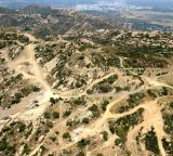
October 2006 look at Fishback Mountain reveals just how extensive the dumping and filling was. Vistas overlook Simi Valley below. Eighteen (18) photographs
18 Photos

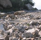
October 2006 photos (continued from Gallery 3) show that just over edge of the fill cliff was broken concrete, tile and rebar. Not “clean fill” according to government regulations. Fifteen (15) photographs
15 Photos

November 2006 - More images of dumping on Fishback's property. A month later, additional aerial shots show extent and soil cover-up. Eighteen (18) photographs
18 Photos

January 2008 - Ventura County officials inspect Fishback’s dump. Large fissures had formed on steep slopes. In February 2008, more shots reveal radical land transformation. Nineteen (19) photographs
19 Photos


Great article by Michael Collins! [MC – “Wild Bill” Bowling is referring to Mountain Wrecker Wayne Fishback Faces Lengthy Jail Time, part of this investigation found above.]
Must we not forget that Fishback led the campaign to downgrade the LA River so the Clean Water Act would not apply and get cozy with Boeing so they will give him the land for his DASH program but it looks like now it’s possible the SSMPA is in line (They were also responsible for lobbying for turning the toxic Nike Missile Base into a park in the watershed of Browns Canyon the other site owned by Mr. Fishback).
This led to the navigability of the Los Angeles River and Lisa Jackson from the EPA declaring it so, then enforcing the Clean Water Act.
The journalists who first wrote about it got it wrong. The writers were told a rancher at the LA River headwaters…then of course they thought the Arroyo Calabasas was the headwaters (It’s a main tributary) so the article starts out “A Calabasas Rancher is challenging the CWA” etc.
Most educated people think Bell Creek is not a headwaters. To get technical – Bell Creek only became the headwaters when the Big and Little Tujunga creeks were dammed up a hundred years ago. These would start in the Verdugo’s and head west then east then into Long Beach – this is why Hanson dam was needed.
By means of record keeping, the Army Corps of Engineers did not really document the LA river and it’s path ways until the floods of 1938 and by then it was a modified river and they declared the headwaters Bell Canyon and hence since forth.
All of this was announced by Lewis MacAdams, Founder of Friends of the Los Angeles River (FoLAR) after several meetings with then Santa Monica Baykeeper and Environment Now helping them lead the charge.
Lewis is quoted in reference to the work of David Beckman saying…”Thank god for the NRDC! The Corps is recommending that the river not be classified as a “traditional navigable water” under the Clean Water Act. Although Rocketdyne is not mentioned specifically, the memo begins:”
“In support of a request for jurisdictional determination for a property owner in the Santa Susana Mountains north of Chatsworth, the drainage system of the Los Angeles River was examined to determine the location of the traditional navigable water (TNW) into which the subject property flows.”
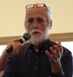
William Preston Bowling
Founder ACME (Aerospace Contamination Museum of Education)